Overview

The Kingdom of Lesotho (pronounced ‘le-soo-too’) lives up to its name as “the kingdom in the Sky” lying at altitudes in excess of 1 300 m above sea-level. It is the country with the highest low point in the world.

It is famous for its breathtaking mountain ranges, towering peaks, a rich variety of flora and fauna, crystal clear streams, surging waterfalls, diverse culture and a snow blanket seen high in the mountains across the country in winter. It is landlocked, nestled between the Drakensberg and Maloti mountain ranges and entirely surrounded by South Africa.

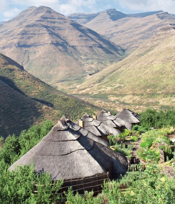
Whether you’re out adrenalin biking, 4×4 driving, hiking or trekking on a Basotho pony, you will not be disappointed. The country offers undulating expanses of pastoral charm, traditional rondavels (round huts with a conical roof) and innumerable grazing sheep.

Scenes of friendly locals passing by on horseback in multicoloured balaclavas and blankets will make you feel very welcome.

Lesotho's Climate

The climate in Lesotho varies essentially with altitude: it is temperate at the lowest elevations, which don’t go, however, below 1 400 metres (4 600 feet), while it gets colder as you go up in altitude. The weather is often unstable, with rapid changes in wind and temperature from day to day.

A long rainy season during the summer months (December to February), combined with freezing conditions in the winter (June to August), creates adverse travel conditions which isolate much of the highland areas. Winter is the driest season, while summer is the rainiest. Snow is more common at high altitudes, above 2 000 metres (6 500 feet), where even rainfall is more abundant.

  • Traditional dress The traditional dress of the Basotho people is a blanket worn as a cloak, that has been carefully selected for its colour and pattern to express individuality and status. Hats (mokorotlo) are woven out of grass into conical shapes.
  • Horse-riding and pony trekking Enjoy the combination of spectacular scenery by day with a glimpse into the traditional lifestyle of the Basotho people by night.
  • Adventure-seeker's paradise The Maletsunyane Falls offer the longest single drop abseil in the world that descends 204 m non-stop to the bottom of the gorge.
  • The highest altitude pub in Africa The highest altitude pub in Africa at 2 874 metres above sea level – offering a refreshing cold beer and amazing views at the end of the iconic Sani Pass.
  • Mountain-biking at high altitude Mountain-biking at high altitude for the fittest out there, involving some serious passes and tricky technical sections.
  • Friendly people and their children Friendly people and their children who seem delighted to have you visit their country.
  • Capital: Maseru
  • Electricity: 220 / 240 volt AC 50Hz
  • Currency: The currency is the “Basotho Loti” (Maloti in plural) and is pegged to the South African Rand at a ratio of 1:1. The Rand is accepted freely everywhere in Lesotho, however, the Loti is not accepted in South Africa.
  • Language: Lesotho has 2 official languages. Sesotho is the national language and spoken by most of the Basotho, and English.
  • Getting Around: When driving a car in Lesotho an International Drivers Licence is recommended. National driving licences are normally valid, provided that they are either in English or accompanied by a certified translation. The road system is underdeveloped and few roads are paved. The main road running through the towns from the north to the western and southern borders is tarred, but other roads can be impassable during the rainy season. We recommend that you do not drive in rural areas at night (nor walk around Maseru at night). Cars can be hired in Maseru and you will need permission from the company to take any car over the border between South Africa and Lesotho. You will have to pay a road tax. Maseru bridge border post is open 24 hours a day but some border posts close at around 6 pm. Some of these border posts can only be reached by four wheel drive. Buses and minibus taxis are good for short routes. Rather than being on a timetabled schedule, buses leave once full, so you're better off buying tickets for any longer journeys in stages, going from town to town rather than direct. Doing it this way means that you're not forced to wait for your bus to fill up at each stop.
  • Airports: South African Air Link has five flights a day from Monday to Friday, four flights on Saturdays, and three flights on Sundays from Moshoeshoe I International Airport to Johannesburg International Airport. The flight takes approximately 1 hour and 15 minutes.

    Area: Lesotho covers a total land area of 30 360 km2 (11 722 sq. miles) which makes it similar in size to Belgium or Israel. The area is ruggedly mountainous, landlocked, and completely surrounded by the Republic of South Africa. It is situated between 28 and 31 degrees South and between 27 and 30 degrees East and lies entirely outside the tropics. Lesotho is the only country in the world which has all its land lying at altitudes in excess of 1 500m (3 280 feet) above sea-level. The mountain, Thabana-Ntlenyana at 3 482 m is the highest in Southern Africa and Maletsunyane Falls are one of the highest single drop waterfalls on the continent, at 192 metres.
  • When to go: Despite the fact that it is the rainiest season, summer (from November to March) is the best season to visit Lesotho because it is sunny and the nights are not as cold as the rest of the year. Days can get hot at lower altitudes, but nights remain cool, so a sweater is a good idea for the evenings. Worth noting is that due to the rains, some mountain roads may be impassable. Spring and autumn are also a good time to go, especially in April, September and October, when the temperatures are mild, but once again consideration should be made for the large differences between night and day. Sunshine is still in abundance and rainfall is possible but not as plentiful. Sometimes during these seasons, however, it can freeze at night, and at high altitudes, it can snow.
  • What to wear: In winter (June to August) in Maseru, wear clothes fit for spring or autumn, with a sweater and a warm jacket for evenings. If you are travelling above 2 000 metres (6 500 feet), wear a down jacket, gloves, scarf, hat and hiking shoes.

    In summer (December to February) in Maseru, wear light clothes during the day, and a sweatshirt and jacket for the evening. You will also need a sun hat, light raincoat or umbrella. For the highest elevations wear a sweatshirt or sweater, a warm jacket and hiking boots.
  • Ts'ehlanyane National Park The Ts'ehlanyane National Park in Northwestern Lesotho features a beautiful 56 km2 patch of rugged wilderness, including one of Lesotho's only stands of indigenous forest, at a high altitude of between 2 000 and 3 000 metres. It is perfect for hiking, horse-riding and even a day hike or pony trek to / from Bokong Nature Reserve, covering some of Lesotho's most dramatic terrain.

    Leribe Leribe (also known as Hlotse) is a busy regional market hub and worth visiting if only to see the dinosaur footprints nearby and its arts and crafts scene.
  • The Katse Dam The Katse Dam is the highest dam in Africa (the surface reaches 2 050 metres when at 100% full) and with 185 metres is the second largest dam wall on the continent. This engineering marvel is a result of the Lesotho Highlands Water Project, a bi-lateral project between the governments of South Africa and Lesotho. It is able to store 1 950 million cubic metres of water which is mainly transferred to South Africa's most populated province of Gauteng. It also generates hydroelectric power for Lesotho.

Destinations in Lesotho